Visiting places in Khyber Pakhtunkhwa Pakistan
It provides an inclusive collections of beautiful pictures of Khyber Pakhtunkhwa and all of the famous and attractive visiting places there. Travel guide about Khyber Pakhtunkhwa is also available to visit various visiting places there to enjoy the best and memorable moments of your life while exploring there.
-
Manshi Top
Manshi Top is a green mountain in the Sharan Forest and accessible through dense thick pine forest. The initial trek is little bit difficult and then it becomes easy to ascend. It takes two hours from Sharan Forest to access the Manshi Top.
Visiting Locations in Manshi Top -
Miandam
Miandam is a lush green hill station located in Swat, Khyber Pakhtunkhwa, Pakistan, in the Hindukush Range at an elevation of 5,900 feet. It is located at a distance of 56 km from Saidu Sharif, Swat. The main road along the Swat River, branches off toward the east side at Fatehpur, and goes into gorgeous hillsides, and reaches the famous hill station of Miandam. It is a very picturesque tourist point. It is a lush green town full of fruit orchards, terraced fields, waterfalls, etc. It is also a base camp for Dadsar baba top, which is a lovely site for hikers.
Visiting Locations in Miandam -
Mingora
Mingora is the head-quarter of Swat city along the Swat River. It is commercial hub for trade for all type of products. The local peoples used to purchases all of their household needs as well as fulfill the needs of all of the retailers in other localities in Swat.
Visiting Locations in Mingora -
Miranjani Top
Miranjani is located in Namli town in Abbaottabad district in Khyber Pakhtunkhwa. it is highest peak in the Galyat Region, at the elevation of 9,814 feet and one of the famous hiking trail for hikkers and tourists. Miranjani Trek is started at the distance of nearly three kilometers from Nathia Gali town.
Visiting Locations in Miranjani Top -
Mukskpuri Top
Mukshpuri or Moshpuri is the second-highest mountain in the Galyat area in Nathia Gali in the district of Abbottabad Khyber Pakhtunkhwa, at an elevation of 9,200 feet. It is just located near Dunga Gali in the area of Ayubia National Park. It is covered with conifer forests and habitat places of different kinds of animals and birds.
Visiting Locations in Mukskpuri Top -
Naran
Naran is a very attractive and pleasant hill station, located in Kaghan valley at the distance of 119 km from Mansehra at the altitude of 8,202 feet. It is most beautiful and scenic location in Pakistan and loving place for trekkers, hikers, and tourists from all over the Pakistan, even from foreign countries.
Visiting Locations in Naran -
Nathia Gali
Nathia Gali is the highest point and hill station in the Galyat area in Abbottabad, and is located at the distance of 82 km from Islamabad via Kashmir Road via Murree. It is fully covered with shades of pine, cedar, walnut, maple, and oak trees. It is popular for its scenic beauty with lush green meadow and forests. Mukshpuri and Miranjani are the two highest peaks of the area, you can also enjoy the trek, with some hiking, to the top of these hills.
Visiting Locations in Nathia Gali -
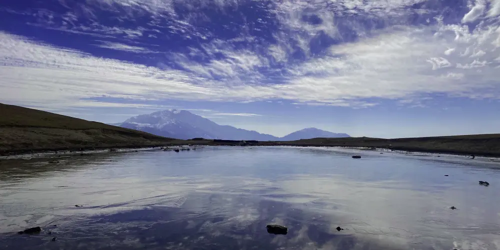
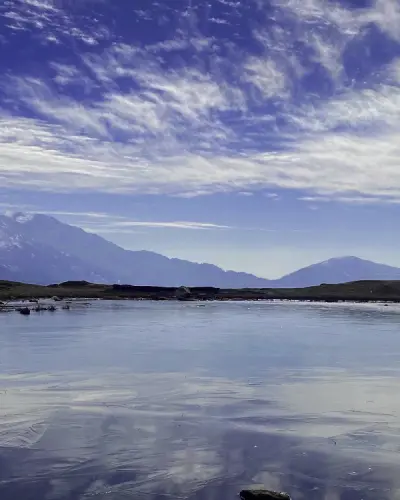
Shandur Lake
Shandur Lake, also known as Chitral Lake, is located in the lush green meadows in the Shandoor Plain. The stunning views of lake are attracted by number tourists every year due to its crystal clear water, pleasant weather, and majestic views of snow-capped mountains around it. The white and dark clouds creations in sky makes it more attractive.
Visiting Locations in Shandur Lake -
Sharan Forest
Sharan Forest is, one of the untouched places in the Kaghan Valley, known for its lush green dense pine forest. It provides a vast landscape with clean environment and healthy atmosphere and preferable place for camping, hiking, and wildlife. It is located near Paras village at the distance of 11.5km and accessible by crossing a bridge over the Khunhar River using jeep.
Visiting Locations in Sharan Forest -
Shimla Peak
-
Shogran
Shogran is located in the Kaghan Valley in Khyber Pakhtoonkhwa province and is one of the famous visiting spots in the valley. This hill station is situated in the midst of green pine trees at a height of 7,749 feet above sea level, at the distance of 34 km from Balakot, and 90 km from Abbottabad.
Visiting Locations in Shogran -
Siri Paye Shogran
Siri Paye meadows is located at the altitude of 7,749 feet above the sea level on the steep slopes in the Kaghan Valley. It is a lush green and fantastic beautiful location on the foot of Makra Peak and Musa Ka Mussala. It is located at the distance of 7 KM from Shogran.
Visiting Locations in Siri Paye Shogran -
Tarbela Dam
Tarbela Dam is constructed on the Indus River in Pakistan, and is the largest earth-filled dam in the world. It is located in Terbela in Khyber Pakhtoonkhwa, at the distance of 50km from Islamabad, on the narrow channel of the Indus River between Haripur and Swabi.
Visiting Locations in Tarbela Dam -
Thandiani
Thandiani, a hill station in the Galyat area, is located at the distance of 16 km from Abbottabad in the foothills of the Himalayas at an altitude of 9,000 feet. Due to the snow-covered Pir Panjal Range in Azad Kashmir, the weather remains pleasant and cool in Thandiani throughout the year.
Visiting Locations in Thandiani -
Zankota Hills
Kandow village is a beautiful village in Karak district on the foot of Zankota Hills. Thre are beautiful views of landscape yellowish grey mountains with touches of green plants. On the top of hill, one can get a bird eye view of Kandow village.
Visiting Locations in Zankota Hills
About Khyber Pakhtunkhwa
Khyber Pakhtunkhwa it the third largest province by population in the northwest of Pakistan. It has well defined history of Hinduism and Buddhism, it was once a part of Gandhara Kingdom, the ruins of its capital Pushkalavati found near Charsadda.
Khyber Pass is an historical pass in the Hindu Kush Range and was merchants route in the Indus Valley Civilization in 3300 BC. Still this Khyber Pass is used as a trade route between Pakistan and Afghanistan. In Mughal Regime, this area was partially under the control of Pashtun Emperor, Sher Shah Suri and some other tribes.
Khyber Paktunkhwa is located on Iranian Plateau and is composed the junction where the Hindu Kush range slopes on the Eurasian Plate, to create a way to the Indus Water. The northern side is normally cold and snowy in winters and pleasant in summers, whereas southern part is arid and hot in summers and cold and rainy in winters. This area stretches from the Sulaiman Mountains to the Indus River.
There are number of beautiful valleys in Khyber Pakhtunkhwa such as Swat, Chitral, Kaghan, Abbottabad, etc, which are well known attraction for tourist in this province.