Hill Stations in Pakistan
Hilly areas in Pakistan is normally composed of number of famous and World's highest mountain peaks. These mountainous valleys are part of famous mountain ranges such as Karakorum, Himalayas, and Hindukush ranges. Due to varying height above the sea level, the weather and temperature normally varies in these mountain and hilly areas. The landscape and structure of the hilly area depicts variety of beautiful and panoramic views that would never be forgotten from your memory. Some of these hilly areas also receive snowfall in winter season which attract number of visitors from all over the World.
Hilly areas which received snowfall in winter are normally known as hill station and there are several famous hill stations in Pakistan. Weather conditions of these hill stations are normally pleasant in the summer season. The mountains with snow around the hill station make it more attractive for tourists These hill stations are the most frequent visiting places specially for family tours.
Here, you explore different Hill Stations in Pakistan with complete travel guides, location maps, and an inclusive collections of photo galleries of these Hill Stations.
Main Categories
Main Category: Hilly Areas
-
Arang Kel Neelum Valley
Arang Kel is a small village near Kel and located on the hilltop at the distance of 2km on the height of 8,379 feet. It is just on the LOC, behind the mountain in front of you. There is no road to the village, so the only way to come here is a chairlift or hiking trek of two hours.
Visiting Locations in Arang Kel Neelum Valley -
Ayubia
Ayubia, also known as Ayubia National Park, is located at the distance of 80 km from Rawalpindi, in Abbottabad, Khyber Pakhtunkhwa. It is situated at an elevation of 8,000 feet above sea level and a large collection of pine forests in Pakistan and has a collection of 104 different species of plants. The climate of Ayubia remains cold in summers and that coldness becomes harsh in winter.
Visiting Locations in Ayubia -
Bahrain
Bahrain is a hill station located in Swat district of KPK 60 km North of Mingora at an elevation of 4700 ft on the right bank of Swat River. It is named Bahrain due to its location at the confluence of the Daral and Swat rivers. It is known for its riverside tourist resorts, local handicrafts, and its view of the confluence of the Daral and Swat Rivers.
Visiting Locations in Bahrain -
Bhurban
Bhurban is located at the distance of 9 km from Murree City at Kashmir Road and a very attractive hill station, at an elevation of 6,000 feet in Murree, Punjab
Visiting Locations in Bhurban -
Chatorkhand
Chatorkhand is the main town in Ishkoman Valley along the Karambar River. It is a deep valley with high mountains. Along the Karambar River, greenery provides a very wonderful view with brownish mountains and snow-capped peaks at the distance.
Visiting Locations in Chatorkhand -
Chillum
Chillum, or Chilam, is the last village in Astore District and is the starting point to start the next journey toward the world highest plain, Deosai. It is also known as Chillum Chowki due to police check post there. It is a lush green area with grazing fields and crops, and number of running streams. Road is not in good condition, but still suitable to continue the journey, there are sharp ascends and descends on the road, which need extra power of vehicle to travel.
Visiting Locations in Chillum -
Chitral
Chitral, a beautiful valley in the Hindukush Range, is located on the western bank of the Chitral River, in the Northwest of Pakistan at the far end border with Afghanistan. Chitral is famous for the scenic beauty of Tirich Mir, which is the highest peak in the Hindukush Range.
Visiting Locations in Chitral -
Chutair Tangi Ziarat
Chutair Tangi is one of the gorges along the road leads Ziarat City. Theare are more than six gorges around Ziarat, which are formed due to sprig water from the mountains. These natural streams in Balochistan are known as Karez.
Visiting Locations in Chutair Tangi Ziarat -
Darkut Village
Darkut is the most beautiful and remote village in the Yasin Valley, located at the distance of 40 km from Yasin town. It is the last village of Pakistan in the Gilgit Baltistan in Gupis-Yasin district at the altitude of 8500 feet on the foot of Ghamubar Zom mountain. There are around 2000 people living in this village. It is a center point for number of important places such as Darkut Pass, Ghamubar Lake, Ghamubar Zom Glacier, etc.
Visiting Locations in Darkut Village -
Dir
Dir is located at a distance of 213 km from Peshawar on the foothills of the Himalayas and is accessible via Chakdara by Dir-Chitral Road and then following Dir-Malakand Road. It was a princely state and ruled by Nawab Shah Jehan Khan and merged with Pakistan in 1969. It is gateway to Chitral in north and to Swat in the east. In 1996, it was divided into Upper Dir district and Lower Dir district.
Visiting Locations in Dir -
Duikar
Duikar is the highest village at the altitude of 10,000 feet in Hunza valley and is located at the distance of 11 km from Karimabad. It is a very interesting point to visit due to its height and you will get a broader view of high mountain peaks in front of you. The most common peaks such as Rakaposhi, Lady Finger, Ultar, Golden peak, etc. can be viewed at this spot.
Visiting Locations in Duikar -
Dunga Gali
Dunga Gali is a very attractive place for the hiker and trekkers as it is the base camp of Mukshpuri top, 9,200 feet high mountain. Dunga Gali has located 87km from Rawalpindi and just after Ayubia, its average elevation is 9,000. There is also a wonderful 4km track from here to Ayubia, that has a lot of beautiful scenes on its trek.
Visiting Locations in Dunga Gali -
Eidgah Astore
Eidgah is the central and capital town of the Astore District. Astore village and Rama Valley are important places for tourist near it. There are a lot of hotels and accommodations for tourists in this area.
Visiting Locations in Eidgah Astore -
Fort Munro
Fort Munro, also known as Tuman Leghari, is a beautiful hill station in the Sulaiman Mountain Range in Southern Punjab at an altitude of 6,470 feet above sea level, in Dera Ghazi Khan. It is located at a distance of 85 km from Dera Ghazi Khan city on Quetta Road. It is my favorite spot in summary due to its cool and pleasant atmosphere.
Visiting Locations in Fort Munro -
Gahkuch
Gahkuch is the capital of Ghizer at the distance of 72km from Gilgit City on Shandur Gilgit Road. It is surrounded by mountains on the bank of the Gilgit River. There are all types of accommodations including PTDC hotel for tourists. It is a lush green valley with high mountains. The view of the Gilgit River in Gahkuch is very of beauty due to the wideness of the river in this area. Another wonderful view is the confluence of the Gilgit River and the Ishkoman River.
Visiting Locations in Gahkuch -
Garam Chashma
Garam Chashma, the highest human settlement in the Hindu Kush Range, is the pleasant valley in Chitral at an altitude of 6,100 feet. It is located at a distance of 45 km from Chitral.
Visiting Locations in Garam Chashma -
Gojal Upper Hunza
Gojal is the largest city in Baltistan next to Hunza, having a border with China and Afghanistan. It connects with China through the Khunjerab Pass and with Afghanistan through the Chapursan Valley. Gojal, also known as Upper Hunza, is the highest mountains area in the Karakoram and Pamir mountain ranges, at an average elevation of 4,000 meters.
Visiting Locations in Gojal Upper Hunza -
Gorikot
Gorikot is the capital and the largest valley of the Astore District. It is a gateway to Nanga Parbat Tarisheng Base camp and to Deosai Plain that link Astore to Skardu. It has lush green plains with beautiful scenic views in the high mountains in attractive colors. Roads from Gorikot are mostly suitable for Jeep but other vehicles can also be used but with some care. It is also famous for fruits and vegetable fields.Gorikot also provides accommodation facilities to stay the night there to start the further journey toward Deosai or Nanga Parbat.
Visiting Locations in Gorikot -
Gulmit
Gulmit, a historical town, is located in mountains, peaks, and glaciers in Gojal Upper Hunza, Gilgit Baltistan at the distance of 140 km from Gilgit on Karakoram Highway on the bank of the Hunza River.
Visiting Locations in Gulmit -
Hattian Bala
Hattian Bala was part of the Baramula district before the ceasefire between India and Pakistan. Then it was part of the Muzaffarabad district. In July 2009, it had got status of district. It is located at the distance of 40 km from Muzaffarabad on the bank of the Jhelum River. It is also part of Jhelum valley that is collection of valleys and mountain ranges around the Jhelum River in Azad Kashmir.
Visiting Locations in Hattian Bala -
Hunza
Hunza, a mountainous valley in Gilgit Baltistan, is situated at a distance of 98 km from Gilgit city. There are several high peaks above 20,000 feet in Hunza Valley and provides a splendid view of many high mountains such Rakaposhi (25,551 ft), Bojahagur Duanasir II (24,045 ft), Ghenta Sar (19, 980 ft), and Hunza Peak (20, 571 ft).
Visiting Locations in Hunza -
Ishkoman
Ishkoman valley is located in Ghizer district, Gilgit Baltistan, Pakistan, at a distance of 140 km from Gilgit City. It will be accessed on the right of Gahkuch along the Karamber River on Karambar River Valley Road. It is a high mountain valley surrounding by snow-capped peaks at an altitude from 7,000 to 12,000 feet in the Hindukush and Karakorum Range. The highest peak near Ishkoman is Shiniki peak, which can be visible from Ishkoman valley.
Visiting Locations in Ishkoman -
Kaghan
Kaghan Valley, a scenic wonderland, is at height of beauty among many beautiful valleys in Hazara in the Khyber Pakhtoonkhwa, Pakistan. It is one hundred and sixty kilometers long valley in the Lower Himalayan mountain range, having an elevation of 2,134 feet to 13,690 feet at Babusar Pass.
Visiting Locations in Kaghan -
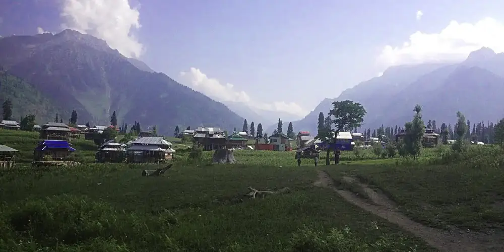
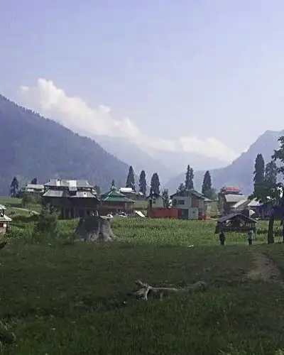
Kalam Valley
Kalam, a cool and pleasant hill station in Hindu Kush Range, is located at the distance of 350 km from Islamabad via Mardan and Malakand on the bank of the Swat River in Khyber Pakhtunkhwa. It is a lush green valley with a thick pine forest, meadows, and waterfalls. The best season to visit Kalam is in the months of April to August. Tourists can enjoy very beautiful and charming views of the Swat River in Kalam.
Visiting Locations in Kalam Valley