Top Tourism Sites and Tour Places in Gojal Upper Hunza Pakistan

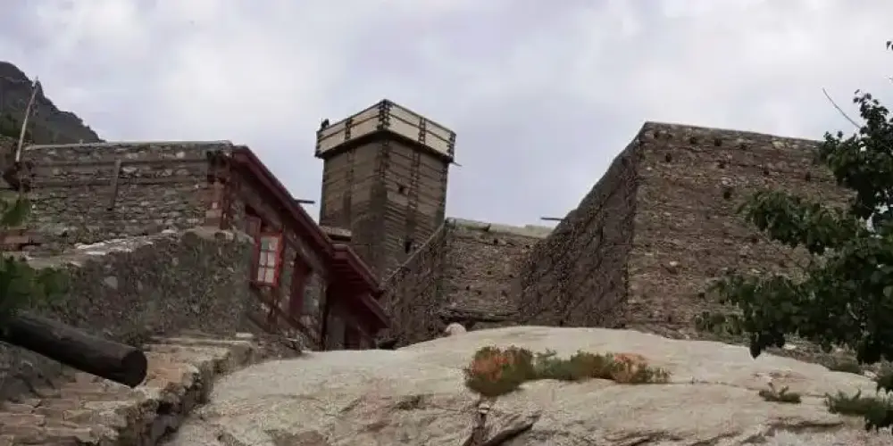
Altit Fort

Click to Zoom.. Altit Fort

Altit Fort, a historical landmark almost 1100 years old, is located on a big rock in Altit village in the Hunza valley at a distance of 5 km from Karimabad on the bank of the Hunza River. It was the old residency of Rulers of Hunza before Baltit Fort, and it is also considered as the oldest building in Gilgit-Baltistan.

Read about Altit Fort

Altit Village

Click to Zoom..
Click to Zoom..

From top of Altit Fort, a broad view of the lush green Altit Village of Hunza can be seen. The historical settlement of Altit village is exceptional restored by Aga Khan Cultural Service. Houses are beautifully crafted within the lush green trees of apricot, walnut, and cherry.

Read about Altit Village

Baltit Fort

Click to Zoom..
Click to Zoom..

Baltit Fort is situated on Old Fort Road in Karamiabad just at the distance of one kilometer on a big rock. It was constructed in 8th century for the daughter of the balti ruler on the top of hill. Fort is presenting in Balti-style with balconies, windows, fireplaces, etc.

Read about Baltit Fort

Duikar

Click to Zoom..
Click to Zoom..

Duikar is the highest village at the altitude of 10,000 feet in Hunza valley and is located at the distance of 11 km from Karimabad. It is a very interesting point to visit due to its height and you will get a broader view of high mountain peaks in front of you. The most common peaks such as Rakaposhi, Lady Finger, Ultar, Golden peak, etc. can be viewed at this spot.

Read about Duikar

Hunza

Click to Zoom..
Click to Zoom..

Hunza, a mountainous valley in Gilgit Baltistan, is situated at a distance of 98 km from Gilgit city. There are several high peaks above 20,000 feet in Hunza Valley and provides a splendid view of many high mountains such Rakaposhi (25,551 ft), Bojahagur Duanasir II (24,045 ft), Ghenta Sar (19, 980 ft), and Hunza Peak (20, 571 ft).

Read about Hunza

Hunza Peak

Click to Zoom..
Click to Zoom..

Hunza Peak is located in Karakoram Range on the right side of Ladyfinger Peak, on the southwest ridge of the Ultar Sar massif in Batura Muztagh. It stands at an altitude of 20,570 feet above sea level. Hunza Peak along with Ladyfinger Peak can be seen from Altit Fort with a beautiful landscape of Hunza Valley.

Read about Hunza Peak

Passu

Click to Zoom..
Click to Zoom..

Passu is a small village located on the Hunza River at the distance of 150 km from Gilgit on the Karakoram Highway next to Gulmit in Gojal on the edge of the Passue Glacier and the Batura Glasier. Passu Cathedral, also known as Passu Cones, at an altitude of 20,033 feet, provides very attractive view for tourists from the Karakoram Highway. The Cathedral Ridge has beautiful view just from the Karakoram Highway near Passu village.

Read about Passu

Passu Cathedral

Click to Zoom..
Click to Zoom..

Passu Cathedral, also known as the Tupopdan Peaks or Passu Cones, is located at the altitude of 20,033 feet in Passu village on Karakoram Highway near the Hunza River. It is the most beautiful picturesque peak in Gilgit-Baltistan. It is worth staying here to get the beauty of this town in the high mountains before moving toward the Khunjerab Pass.

Read about Passu Cathedral

Shimshal

Click to Zoom..
Click to Zoom..

Shimshal is a largest village located in Hunza district in Gilgit-Baltistan on Pakistan China Border. It is the highest settlement in the Hunza district at the altitude of 10,170 feet above the sea level, and located at 210 KM from Gilgit City. Shimshal valley is scattered around the Shimshal River that is a tributary of the Hunza River.

Read about Shimshal

Sost

Click to Zoom..
Click to Zoom..

Sost is the last town in Gojal, Gilgit-Baltistan, Pakistan at the distance of 184 km from main Gilgit city on Karakoram Highway before China Border at Khunjerab Pass. It is the last town at an elevation of 2,800 meters inside Pakistan on the Karakoram Highway before the Chinese border.

Read about Sost