Hilly Areas in Pakistan
Hilly areas in Pakistan is normally composed of number of famous and World's highest mountain peaks. These mountainous valleys are part of famous mountain ranges such as Karakorum, Himalayas, and Hindukush ranges. Due to varying height above the sea level, the weather and temperature normally varies in these mountain and hilly areas. The landscape and structure of the hilly area depicts variety of beautiful and panoramic views that would never be forgotten from your memory. Some of these hilly areas also receive snowfall in winter season which attract number of visitors from all over the World.
Hilly areas which received snowfall in winter are normally known as hill station and there are several famous hill stations in Pakistan. Weather conditions of these hill stations are normally pleasant in the summer season. The mountains with snow around the hill station make it more attractive for tourists These hill stations are the most frequent visiting places specially for family tours.
Here, you explore different Hilly Areas in Pakistan with complete travel guides, location maps, and an inclusive collections of photo galleries of these Hilly Areas.
Main Categories
Sub Categories: Glaciers | Hill Stations | Mountain Passes | Mountain Peaks | Mountainous valleys
-
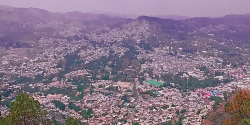
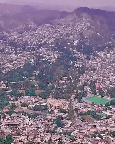
Abbottabad
Abbottabad, a gateway to Northern Areas, is situated in Hazara, Khyber Pakhtunkhwa at an elevation of 4,121 feet at a distance of 110 km from Islamabad capital of Pakistan. Abbottabad is famous for its pleasant weather due to its border with Kashmir and Murree.
Visiting Locations in Abbottabad -
Arang Kel Neelum Valley
Arang Kel is a small village near Kel and located on the hilltop at the distance of 2km on the height of 8,379 feet. It is just on the LOC, behind the mountain in front of you. There is no road to the village, so the only way to come here is a chairlift or hiking trek of two hours.
Visiting Locations in Arang Kel Neelum Valley -
Astore
Astore is district in the Gilgit-Baltistan and located at an altitude of 8,500 feet on the eastern side of Mount Nanga Parbat in front of the Rupal Face, at the distance of 60 km from Gilgit main city. Astore region ascends from the Indus River from Jaglot toward the opposite side of the Diamer district.
Visiting Locations in Astore -
Attock
Attock is located on the bank of the River Indus on the Pothohar Plateau, at the distance of 80 km from Rawalpindi and 100 km from Peshawar. Attock is famous for the magnificent view of the merger of the River Indus and Kabul River that is visible from the bridge over the River Indus on Grand Trunk Road.
Visiting Locations in Attock -
Ayubia
Ayubia, also known as Ayubia National Park, is located at the distance of 80 km from Rawalpindi, in Abbottabad, Khyber Pakhtunkhwa. It is situated at an elevation of 8,000 feet above sea level and a large collection of pine forests in Pakistan and has a collection of 104 different species of plants. The climate of Ayubia remains cold in summers and that coldness becomes harsh in winter.
Visiting Locations in Ayubia -
Babusar Pass
Babusar Pass, the highest mountain pass in Kaghan Valley, is located at a distance of 66km from Naran. It is very cold even in the summer. It connects Khyber Pakhtunkhwa with Chilas, Gilgit Baltistan with Korakuram Highway.
Visiting Locations in Babusar Pass -
Bagh
Bagh is a mountainous and lush green area of Azad Kashmir in the Himalayas and Pir Panjal Range at an average elevation of between 1,500 to 2,500 meters above sea level. It is located at the distance of 88km from Muzaffarabad via Sudhan Gali on Sudhan Gali Road along the Mahl River with number of rivulets. These mountains are covered with coniferous forests. It was part of Poonch district before 1988, when it was given a status of district.
Visiting Locations in Bagh -
Bahrain
Bahrain is a hill station located in Swat district of KPK 60 km North of Mingora at an elevation of 4700 ft on the right bank of Swat River. It is named Bahrain due to its location at the confluence of the Daral and Swat rivers. It is known for its riverside tourist resorts, local handicrafts, and its view of the confluence of the Daral and Swat Rivers.
Visiting Locations in Bahrain -
Bajaur Agency
Bajaur is the smallest agency in the Federally Administered Tribal Areas, FATA. Its land structure is mostly hilly terrain. Most of the mountain ranges in Bajaur are lush green, with small streams. Its weather remains pleasant due to Swat valley in the east. It is located at the distance of 195 km from Peshawar and accessible via Malakand Mardan Road and N-45.
Visiting Locations in Bajaur Agency -
Balakot
Balakot is the most important town in the Mansehra district in Khyber Pakhtunkhwa and is located on the right bank of the Kunhar River. The Kunhar River flows in a very clam channel after crossing Balakot instead of narrow and sharp gorges in the Kaghan Valley.
Visiting Locations in Balakot -
Balochistan
Balochistan is the largest province by area and located in the southwest side of Pakistan. Balochistan has the least number of popluation but has its importance due to vast mineral resouces including oil and gas. The natural gas resouces are the second largest resouces in the World. Another development in Balochistan is the deep sea port in Gwadar, which will be main transit point for international trade between China and rest of the World.
Visiting Locations in Balochistan -
Bannu
Bannu is situated at a distance of 198 km from Peshawar on the basin drained by the Kurram River and the Tochi River, flowing from Waziristan Hills. It has very fertile land, located on the foot of frontier hills and surrounded by rugged and dry mountains.
Visiting Locations in Bannu -
Battagram
Battagram is located in the Karakorum Range having an elevation of 3406 feet, at the distance of 291 km from Peshawar in Khyber Pakhtoonkhwa, and is accessible via Mansehra on the Karakoram Highway N-35. It is located at the lusg green deep forest area in the Karakorum Range.<
Visiting Locations in Battagram -
Bhimber
Bhimber, also known as Baab-e-Kashmir, is situated at the distance of 50 km from Mirpur on the border between Kashmir and Punjab. It was historically on the location on the route that was followed by the Mughals to visit the Kashmir Valley. It was got the status of district in 1996.
Visiting Locations in Bhimber -
Bhurban
Bhurban is located at the distance of 9 km from Murree City at Kashmir Road and a very attractive hill station, at an elevation of 6,000 feet in Murree, Punjab
Visiting Locations in Bhurban -
Bolan pass
Bolan Pass connects Central Asia and South Asia. It has a historical background, it was the main gateway to cross the region for invaders, traders, and nomadic tribes. It is located in Toba Kakar Range in Balochistan between Quetta and Sibi, mountains are dry and barren. Traveling through the pass is the real adventure of crossing dry and dusty mountains through a number of narrow gorges of 89 km in length. Traveling through rail is more interesting while crossing Bolan Pass.
Visiting Locations in Bolan pass -
Buner
Buner is located at the distance of 142 km from Peshawar via Mardan and Charguli in Khyber Pakhtoonkhwa. It is a mountain valley, surrounded by mountain ranges such as Ilam Range, the Duma Range, the Guru mountains, and the Sinawar Range.
Visiting Locations in Buner -
Chagai
Chagai is the largest district of Pakistan and is situated on the north west part of Balochistan, at the distance of 560 km from Quetta city on the Quetta-Taftan Highway N-40. The importance of this district is due to international border between Iran and Pakistan at Taftan to link with Zahedan city in Iran.
Visiting Locations in Chagai -
Chakwal
Chakwal is located in the Dhanni region in Potohar Plateau at the distance of 90 km from Islamabad, and accessed from Lahore - Islamabad Motorway M-2 near Kallar Kahar. It is also known as land of army people as number of locals are serving in armed forces.
Visiting Locations in Chakwal -
Chaman
Chaman is situated in Balochistan with Kandahar, a city of Afghanistan, at the distance of 128 km from Quetta on National Highway N-25. It is the most important border crossing between Pakistan and Afghanistan, and most of the trade is conducted through it.
Visiting Locations in Chaman -
Chatorkhand
Chatorkhand is the main town in Ishkoman Valley along the Karambar River. It is a deep valley with high mountains. Along the Karambar River, greenery provides a very wonderful view with brownish mountains and snow-capped peaks at the distance.
Visiting Locations in Chatorkhand -
Chilas
Chilas is the capital town of Diamer district on the Karakoram Highway on the left side of the Indus River at the foot of Nanga Parbat. It is located at an elevation of 3,000 feet above sea level at a distance of 471 km from Islamabad via Besham through KKH and Hazara Motorway M-15. It is also accessible via Naran, Kaghan Valley, in less time by crossing Babusar Top.
Visiting Locations in Chilas -
Chillum
Chillum, or Chilam, is the last village in Astore District and is the gateway to start the next journey toward the world highest plain known as Deosai. It is also known as Chillum Chowki due to police check post there. It is a lush green area with grazing fields and crops, and number of running streams.
Visiting Locations in Chillum -
Chitral
Chitral, a beautiful valley in the Hindukush Range, is located on the western bank of the Chitral River, in the Northwest of Pakistan at the far end border with Afghanistan. Chitral is famous for the scenic beauty of Tirich Mir, which is the highest peak in the Hindukush Range.
Visiting Locations in Chitral