Beautiful Hilly Areas in Pakistan
Hilly areas is normally composed of number of famous and World's highest mountains. Due to varying height above the sea level, the weather and temperature normally varies in these mountains and hilly areas, as well as the landscape and structure of the hilly area depicts variety of beautiful views that would never be forgotten from your memory. Some of these hilly areas also receive snowfall in winter season which attract number of visitors from all over the World.
Hilly areas which received snowfall in winter are normally known as hill station and there are famous hill stations in Pakistan which attract tourists from all over the World. Weather conditions of these hill stations are normally pleasant in the summer season. These are the most frequent tour places specially for family tours.
Here, you may explore an inclusive collections of beautiful pictures of Hilly Areas in Pakistan.
Main Categories
Sub Categories: Glaciers | Hill Stations | Mountain Passes | Mountain Peaks | Mountaineous valleys
-
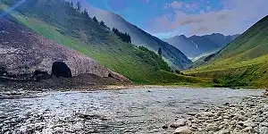
Gupis Yasin
Hill StationsGupis Yasin is located in the west of Gilgit-Baltistan in the high mountains of the Hindu Kush Range at a distance of 187 KM from the Gilgit main city. It is given the status of district in 2019 and separated from Ghizer district including Gupis, Yasin, and Phander Tehsil.
Visiting Locations in Gupis Yasin -
Hangu
Mountaineous valleysHangu is located at the distance of 109 km from Peshawar via Kohat on Kohat-Hangu Road. It is located next to Kohat at the distance of 30 KM. It is a beautiful town with lush green mountains and valleys. Its name is due to some expected Chinese travelers as there is town in China with same name.
Visiting Locations in Hangu -
Haripur
Mountaineous valleysHaripur is situated in Hazara at the distance of 160 km from Peshawar on Karakorum Highway N35 on the bank of the Dor River, at an altitude of 2,000 feet. It was also the main city in the ancient Gandhara civilization. Mostly, it has hilly plain area with deep forest.
Visiting Locations in Haripur -
Hattian Bala
Hill StationsHattian Bala was part of the Baramula district before the ceasefire between India and Pakistan. Then it was part of the Muzaffarabad district. In July 2009, it had got status of district. It is located at the distance of 40 km from Muzaffarabad on the bank of the Jhelum River. It is also part of Jhelum valley that is collection of valleys and mountain ranges around the Jhelum River in Azad Kashmir.
Visiting Locations in Hattian Bala -
Haveli
Mountaineous valleysHaveli is a district in Azad Kashmir and is located on an elevation of 8,000 feet at the distance of 141 km from Muzaffarabad. It is accessible via Kohala through Bagh Highway and then following Dhulli Road. It is covered by Indian-Occupied Jammu & Kashmir from its three sides with the Baramulla district.
Visiting Locations in Haveli -
Hunza
Hill StationsHunza, a mountainous valley in Gilgit Baltistan, is situated at a distance of 98 km from Gilgit city. There are several high peaks above 20,000 feet in Hunza Valley and provides a splendid view of many high mountains such Rakaposhi (25,551 ft), Bojahagur Duanasir II (24,045 ft), Ghenta Sar (19, 980 ft), and Hunza Peak (20, 571 ft).
Visiting Locations in Hunza -
Hunza Peak
Mountain PeaksHunza Peak is located in Karakoram Range on the right side of Ladyfinger Peak, on the southwest ridge of the Ultar Sar massif in Batura Muztagh, at an altitude of 20,570 feet. Ladyfinger, Bublimating Peak, is a distinctive rock spire and snowless peak at this height of 20,000 feet. Both can also be seen from Altit fort within a beautiful landscape of Hunza valley.
Visiting Locations in Hunza Peak -
Ishkoman
Hill StationsIshkoman valley is located in Ghizer district, Gilgit Baltistan, Pakistan, at a distance of 140 km from Gilgit City. It will be accessed on the right of Gahkuch along the Karamber River on Karambar River Valley Road. It is a high mountain valley surrounding by snow-capped peaks at an altitude from 7,000 to 12,000 feet in the Hindukush and Karakorum Range. The highest peak near Ishkoman is Shiniki peak, which can be visible from Ishkoman valley.
Visiting Locations in Ishkoman -
Jaglot
Mountaineous valleysJaglot is situated in the Gilgit District at a distance of 45 km from Gilgit city on the Karakoram Highway. It is a very important town in Gilgit as it is a junction point of three main mountain ranges, the Hindukush, the Karakoram, and the Himalayas. It is also the confluence point of the Gilgit River and the Indus River. It is also a gateway to the Gilgit district as well as the Skardu district.
Visiting Locations in Jaglot -
Jaglot Town
Hill StationsJaglot is important town as it is the gateway of Gilgit as well as Skardu. There is a bridge over the Gilgit River which connects it with Skardu on the Skardu Road along the Indus River, whereas on the Karakoram Highway Gilgit and other districts of Gilgit-Baltistan are accessed.
Visiting Locations in Jaglot Town -
Jhelum
Mountaineous valleysJhelum is situated in Pothohar Plateau, on the east bank of the Jhelum River, in the north of Punjab, Pakistan. Jhelum is famous for the number of soldiers in the Pakistan Army as well as in British Army before independence, so it is known as city of soldiers.
Visiting Locations in Jhelum -
Kaghan
Hill StationsKaghan Valley, a scenic wonderland, is at height of beauty among many beautiful valleys in Hazara in the Khyber Pakhtoonkhwa, Pakistan. It is one hundred and sixty kilometers long valley in the Lower Himalayan mountain range, having an elevation of 2,134 feet to 13,690 feet at Babusar Pass.
Visiting Locations in Kaghan -
Kalabagh
Mountaineous valleysKalabagh is situated in Mianwali District in Punjab, at the distance of 415 km from Lahore, turn left from Islamabad-Lahore Motorway M-2 on Talagang-Chakwal Road, on the western bank of the Indus River in the Salt Range, and a wonderful scenic views of the Indus River through the hills.
Visiting Locations in Kalabagh -
Kalam Valley
Hill StationsKalam, a cool and pleasant hill station in Hindu Kush Range, is located at the distance of 350 km from Islamabad via Mardan and Malakand on the bank of the Swat River in Khyber Pakhtunkhwa. It is a lush green valley with a thick pine forest, meadows, and waterfalls. The best season to visit Kalam is in the months of April to August. Tourists can enjoy very beautiful and charming views of the Swat River in Kalam.
Visiting Locations in Kalam Valley -
Kalat
Mountaineous valleysKalat is a district in Balochistan Province at the distance of 141 km from Quetta on Karachi-Quetta Highway N-25. It was the main land of the princely state of the Khanate of Kalat from 1512 to 1955.
Visiting Locations in Kalat -
Kallar Kahar
Mountaineous valleysKallar Kahar, a valley of peacocks, is located in Chakwal district at a distance of 250km from Lahore on Islamabad-Lahore Motorway M2. It is famous for its beautiful saltwater lakes and natural garden of loquat trees, with wildlife especially peacocks.
Visiting Locations in Kallar Kahar -
Karak
Mountaineous valleysKarak is a district in Khyber Pakhtoonkhwa at the distance of 139 km from Peshawar main city on Indus Highway N-55. Its landscape is composed of barren mountains but rich with natural minerals such as oil, gas, salt and uranium, etc.
Visiting Locations in Karak -
Karimabad
Hill StationsKarimabad, also known as Baltit, is the capital of Hunza Valley in Gilgit-Baltistan, located at the distance of 100 km from Gilgit main city on the west bank of the Hunza River. It is the best tourist spot in Pakistan especially Baltiti Fort and Karimabad village are the main attraction of this area. Karimabad town, located on the west bank of the Hunza River, the landscape of Karimabad is made up of huge steep sloping terraces.
Visiting Locations in Karimabad -
Kaschanatar
Hill StationsKaschanatar is located near LOC, next to Bhimber in Azad Kashmir, at a distance of 117 km from Islamabad at an altitude of 390 meters. The Himalayan ranges in this valley are low-lying foothills so local residents make the forms by carving for irrigating crops such as wheat and corn. The Chanar stream flows in the center of the valley and is the main source of water for irrigation and other usages. This valley has historical importance, as the area was remained in use by Mughal Emperors 200 years ago.
Visiting Locations in Kaschanatar -
Kel
Hill StationsKel is the most attractive and charming location for tourists at the altitude of 6,879 feet at a distance of 155 km from Muzaffarabad in Neelum Valley. It is the base camp to start your journey toward Taobat, Shounter Valley, Chitta Katha Lake, and Arang Kel.
Visiting Locations in Kel -
Kenhatti Village
Hilly AreasIn Kenhatti Garden, a traditional style Punjabi village is located, which becomes a main attraction for visitors. Passage is defined to move inside the village and house around the passage are decorated well to attract tourists. You are not allowed to enter inner streets of village nor even in adjoining houses.
Visiting Locations in Kenhatti Village -
Keran
Hill StationsOn the bank of Neelum River and just on the LOC, there is a beautiful valley called Keran at the altitude of 5,000 feet. There is a splendid view of the Neelum River at this point and one can enjoy fishing there too. Upper Keran is more beautiful small village at the top, and you can have a clear view of mountain ranges in the Indian held Kashmir there.
Visiting Locations in Keran -
Khabaiki Village
Mountaineous valleysJust before Khabbaki lake, the Khabbaki village is just located on the main Naushehra-Jaba Road. From the main road inside the Khabbaki village, small lake called Khabeki is located.
Visiting Locations in Khabaiki Village -
Kharmang
Mountaineous valleysKharmang is a district in Gilgit-Baltistan at a distance of 311 km from Gilgit City on the banks of the Indus River along Kargil-Skardu Road. It is located on the Control Line between Pakistan and India, with Kargil district of Indian-Occupied Jumma & Kashmir.
Visiting Locations in Kharmang