Beautiful Hilly Areas in Pakistan
Hilly areas is normally composed of number of famous and World's highest mountains. Due to varying height above the sea level, the weather and temperature normally varies in these mountains and hilly areas, as well as the landscape and structure of the hilly area depicts variety of beautiful views that would never be forgotten from your memory. Some of these hilly areas also receive snowfall in winter season which attract number of visitors from all over the World.
Hilly areas which received snowfall in winter are normally known as hill station and there are famous hill stations in Pakistan which attract tourists from all over the World. Weather conditions of these hill stations are normally pleasant in the summer season. These are the most frequent tour places specially for family tours.
Here, you may explore an inclusive collections of beautiful pictures of Hilly Areas in Pakistan.
Main Categories
Sub Categories: Glaciers | Hill Stations | Mountain Passes | Mountain Peaks | Mountaineous valleys
-
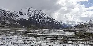
Khunjerab Pass
Mountain PassesKhunjerab Pass is a gateway between Pakistan and China, at an elevation of 15,397 feet in the Karakoram Range in Nagar, Gilgit. It is the highest border crossing in the World and is located at a distance of 270km from Gilgit main city.
Visiting Locations in Khunjerab Pass -
Khushab
Mountaineous valleysKhushab, meaning sweet water, is situated near the Jhelum River in Punjab at the distance of 250 km from Lahore, next to Sargodha on Islamabad-Lahore Motorway M-2, on the left from Bhularwan interchange via Bhalwal or from Sial Interchange on Lahore-Sargodha Road, National Highway N-60 at the distance of 232 km from Lahore.
Visiting Locations in Khushab -
Khuzdar
Mountaineous valleysKhuzdar is located at the distance of 302 km from Quetta City on the Karachi-Quetta Highway N-25. It is a historical city and was the capital of the Khanate of Kalat that was a princely state of the Brahui Kingdom of Makran.
Visiting Locations in Khuzdar -
Khyber Agency
Mountaineous valleysKhyber is one of the famous agency under the Federally Administered Tribal Areas, FATA, and located at the distance of 67 km from Peshawar on National Highway N-5. Khyber Pass is one the main site in khyber agency and one of the major pass to cross border between Afghanistan and Pakistan.
Visiting Locations in Khyber Agency -
Killa Abdullah
Mountaineous valleysKilla Abdullah is a district in Balochistan Province at the distance of 105 km from Quetta. It is mountainuous region situated in the foothills of the Shela Bagh Range. It is accessible via Khojak tunnel or Khojak Pass through Chaman Road N-25.
Visiting Locations in Killa Abdullah -
Kohat
Mountaineous valleysKohat is located on the right bank of the Indus River at the distance of 72 KM from Peshawar on Indus Highway N-55 after crossing Kohat Pass. It is located at an altitude of 489 metres from the sea level. In the British Regime, there were a number of military cantonments in the city, so it was an important strategic city for the British.
Visiting Locations in Kohat -
Kohistan
Mountaineous valleysKohistan is an administrative region and covering an area around the Indus River next to Battagram on Karakoram Highway in the Hazara region in Khyber Pakhtoonkhwa. It is located at a distance of 421 km from Peshawar to its head quarter Dasu. It is the main connecting point with Gilgit-Baltistan via Karakoram Highway.
Visiting Locations in Kohistan -
Kotli
Mountaineous valleysKotli is the most populous district of Kashmir and is situated along the Poonch River at a distance of 136 km from Rawalpindi. From Motorway N5 near Rawat Fort, move on Kallar Syedan-Dadyal Road and finally turn left to join Kotli Road in Mirpur to access Kotli.
Visiting Locations in Kotli -
Kumrat Valley
Hill StationsKumrat valley is located at the distance of 302 km from Peshawar in the Upper Dir, Khyber Pakhtunkhwa. It is accessible through Dir Road via National Highway N-45. It is an attractive place for tourists with full of picturesque places to visit.
Visiting Locations in Kumrat Valley -
Kurram Agency
Mountaineous valleysKurram Agency is located at the distance of 218 km from Peshawar and accessible via Thall-Hangu Road. Its name is derived from the Kurram River, that flows across this valley, which enters in Pakistan from Afghanistan and finally merges with the Indus River near Isa Khel.
Visiting Locations in Kurram Agency -
Ladyfinger Peak
Mountain PeaksLadyfinger Peak is one the highest rock spire peak without snow. It is situated along the Hunza Peak on the southwest ridge of the Ultar Sar massif in Batura Muztagh and clearly visible from Hunza Valley.
Visiting Locations in Ladyfinger Peak -
Lalazar
Hill StationsLalazar is a beautiful lush green meadow with colorful wildflowers within a pine forest, it is situated at the distance of 21 km from Naran at an elevation of 10,499 feet. It is accessible through the jeep and the trek has wonderful scenes as the River Kunhas is flowing on side of the trek. It is also a lovely spot for camping in the Kaghan Valley and a good place to observe wildlife there too.
Visiting Locations in Lalazar -
Leepa Valley
Hill StationsThe Valley is located at a distance of 105 km on metaled road from Muzaffarabad in Azad Kashmir, Pakistan. It is an attractive place for tourists, situated on mountains covered with pine trees. It can be accessed from Muzaffarabad to Reshian which is at an altitude of 10500 feet at sea level and then a jeep must be hired to cover the remaining 38 km, descends into the valley at an altitude of 5500 feet at sea level. Tourist visits this valley to enjoy its splendid beauty. The overall valley is divided into Reshian, Leepa, Chananian, and Reshian Dao Khan.
Visiting Locations in Leepa Valley -
Malakand
Mountain PassesMalakand is located at a distance of 86 km from Peshawar via Mardan on Malankand-Mardan Road. It has very important strategic location as a gateway to Bajaur, Swat, Buner, and Lower Dir. It is surrounded by barren mountains, where Malakand Pass connects Mardan to Swat and to Dir near Dargai.
Visiting Locations in Malakand -
Malam Jabba
Hill StationsMalam Jabba is a very charming hill station in the Hindukush Range at the distance of 40km from Saidu Sharif in Swat Valley. It is the only ski resort in Pakistan. It is equipped with various facilities including ice-skating, roller, chair lift, skiing platforms, cable car, snowboarding, etc.
Visiting Locations in Malam Jabba -
Mansehra
Hill StationsMansehra is located at the distance of 221 km from Peshawar on Karakoram Highwary N-35. It is very important location as a gateway to Gilgit-Baltistan through Karakoram Highway or through Babusar Pass in the Kaghan Valley. It has very pleasant weather due to surrounding valleys such as Kaghan and Kashmir.
Visiting Locations in Mansehra -
Mardan
Mountaineous valleysMardan is situated at a distance of 61 km from Peshawar on Nowshera-Mardan Road. It is also linked the Swat Express Highway M-16, which can be used to bypass the Malakand Pass to access Swat, Dir, Chitral districts.
Visiting Locations in Mardan -
Margalla Hills
Mountain PeaksThe Margalla Hills is a part of Himalayan foothills, located on the north of Islamabad, Pakistan. The Margalla Hills has an average elevation of 1000 meters. Tilla Charouni is the highest peak in this range. It also gets snowfall in the winter season. These hills have an attractive greenish view around the north side of Islamabad and provide a relaxing view for tourists. Pir Sohawa is the highest tourist spot in this area.
Visiting Locations in Margalla Hills -
Miandam
Hill StationsMiandam is a lush green hill station located in Swat, Khyber Pakhtunkhwa, Pakistan, in the Hindukush Range at an elevation of 5,900 feet. It is located at a distance of 56 km from Saidu Sharif, Swat. The main road along the Swat River, branches off toward the east side at Fatehpur, and goes into gorgeous hillsides, and reaches the famous hill station of Miandam. It is a very picturesque tourist point. It is a lush green town full of fruit orchards, terraced fields, waterfalls, etc. It is also a base camp for Dadsar baba top, which is a lovely site for hikers.
Visiting Locations in Miandam -
Minawar
Mountaineous valleysMinawar is located at 8 km from Gilgit City on Karakoram Highway after Chhamugarh in Gilgit District.
Visiting Locations in Minawar -
Minimarg
Hill StationsMinimarg is a very attractive village in the Neelum Valley in Azad Kashmir, located on the right bank of the Kishenganga River, also called Neelum River, at an altitude of 2,845 meter. It is located at the distance of 536 km from Islamabad and accessible via Mansehra - Naran - Jalkhan, Chilas, then through the Karakoram Highway, turn left after passing Raikot Bridge on the Astore Valley Road, this road leads toward Minimarg after crossing the Azad Kashmir Border. Access through Neelum Vally is short but more difficult, only trekking and jeep tracks are available to access it.
Visiting Locations in Minimarg -
Mohmand Agency
Mountaineous valleysMohmand Agency is under the control of the Federally Administered Tribal Areas, FATA, and is located at the distance of 87 km from Peshawar and accessible via Charsadda-Mohmand Agency Road. Its landscape is mostly covered with rocky and rugged mountains with number of barren plains.
Visiting Locations in Mohmand Agency -
Mount Sakesar
Mountain PeaksSakesar Mountain is the highest point at the elevation of 1,522 meters in the Salt Range in the Soon Valley. In winter season, it also receives littlebit snowfall. It is restricted area now due to PAF airbase and radar system on top of the Sakesar, but tourist can visit its top if some of the armed force link available.
Visiting Locations in Mount Sakesar -
Mukskpuri Top
Mountain PeaksMukshpuri or Moshpuri is the second-highest mountain in the Galyat area in Nathia Gali in the district of Abbottabad Khyber Pakhtunkhwa, at an elevation of 9,200 feet. It is just located near Dunga Gali in the area of Ayubia National Park. It is covered with conifer forests and habitat places of different kinds of animals and birds.
Visiting Locations in Mukskpuri Top