Top 10 beautiful Hill Stations in Gilgit Baltistan
Here, you may explore list of famous tourist locations in Pakistan to visit. You can also explore travel guides and maps to visit these Hill Stations in Pakistan to enjoy the most memorable days of your life.
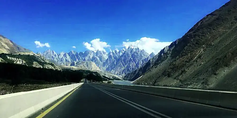
Passu is a small village located on the Hunza River at an elevation of 8,117 feet at the distance of 150 km from Gilgit on the Karakoram Highway. It is one of the beautiful valley of Gojal Upper Hunza and famous for the magnificent and panoramic view of Passu Cones from the KKH.
Gojal is the largest city in Baltistan next to Hunza, having a border with China and Afghanistan. It connects with China through the Khunjerab Pass and with Afghanistan through the Chapursan Valley. Gojal, also known as Upper Hunza, is the highest mountains area in the Karakoram and Pamir mountain ranges, at an average elevation of 4,000 meters.
Shukargah is one of the beautiful valleys in Gizer near Chatorkhand in Ishkoman Valley. Along the Hayool Gol, there broader and deeper valley with lush green meadows and streams. There is also a number of beautiful and attractive lakes in this area.
Ishkoman valley is located in Ghizer district, Gilgit Baltistan, Pakistan, at a distance of 140 km from Gilgit City. It will be accessed on the right of Gahkuch along the Karamber River on Karambar River Valley Road. It is a high mountain valley surrounding by snow-capped peaks at an altitude from 7,000 to 12,000 feet in the Hindukush and Karakorum Range. The highest peak near Ishkoman is Shiniki peak, which can be visible from Ishkoman valley.
Yasin Valley, Babaye-e-Yasen, is a valley in Hindu Kush Range at an average altitude of 26,00 meters, in Gupis-Yasin district, Baltistan, at the distance of 128 km from Gilgit main city and accessible through Chitral Road from Gilgit along the Gilgit River. From Gupis town, turn right on Yasin Valley Road along the Yasin River to access it.
Gulmit, a historical town, is located in mountains, peaks, and glaciers in Gojal Upper Hunza, Gilgit Baltistan at the distance of 140 km from Gilgit on Karakoram Highway on the bank of the Hunza River.
Chillum, or Chilam, is the last village in Astore District and is the gateway to start the next journey toward the world highest plain known as Deosai. It is also known as Chillum Chowki due to police check post there. It is a lush green area with grazing fields and crops, and number of running streams.
Skardu is the main hub for tourism, trekking, and expedition in the Gilgit-Baltistan. The mountainous terrain of the region with four of the world's 14 Eight-thousander peaks, attracts people around the world having an interest in trekking, mountaineering, etc.
Phander valley is located in Gupis-Yasin district in Gilgit-Baltistan at the distance of 184 KM from Gilgit. The valley is quite flat like a palm, that's why it is called Phander as meaning of Phan is palm in Khowar language, local language of the region.
Minimarg is a very attractive village on an elevation of 2,845 meters in the Neelum Valley on the right bank of the Kishenganga River, also known as Neelum River. Geographically, it is located in Azad Kashmir, but it is mostly accessible from Astore Gilgit-Baltisan.