Visiting places in Gilgit Baltistan Pakistan
It provides an inclusive collections of beautiful pictures of Gilgit Baltistan and all of the famous and attractive visiting places there. Travel guide about Gilgit Baltistan is also available to visit various visiting places there to enjoy the best and memorable moments of your life while exploring there.
-
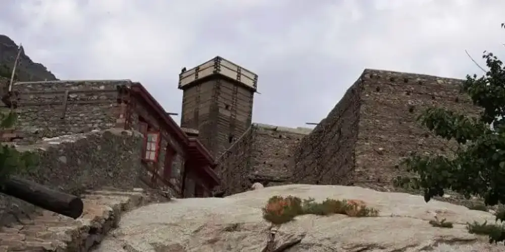
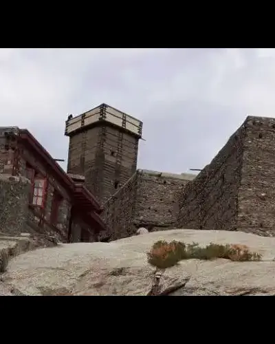
Altit Fort
Altit Fort, a historical landmark almost 1100 years old, is located on a big rock in Altit village in the Hunza valley at a distance of 5 km from Karimabad on the bank of the Hunza River. It was the old residency of Rulers of Hunza before Baltit Fort, and it is also considered as the oldest building in Gilgit-Baltistan.
Visiting Locations in Altit Fort -
Altit Village
From top of Altit Fort, a broad view of the lush green Altit Village of Hunza can be seen. The historical settlement of Altit village is exceptional restored by Aga Khan Cultural Service. Houses are beautifully crafted within the lush green trees of apricot, walnut, and cherry.
Visiting Locations in Altit Village -
Attabad Lake
Attabad Lake, also known as Gojal Lake, is located in Gojal valley in Gilgit Baltistan at the distance of 122 km from Gilgit main city on Karakoram Highway. It was created accidentally in January 2010 by a massive landslide in Attabad village.
Visiting Locations in Attabad Lake -
Baltit Fort
Baltit Fort is situated on Old Fort Road in Karamiabad just at the distance of one kilometer on a big rock. It was constructed in 8th century for the daughter of the balti ruler on the top of hill. Fort is presenting in Balti-style with balconies, windows, fireplaces, etc.
Visiting Locations in Baltit Fort -
Baltit Fort Museum
There is wounderful museum in Baltit Fort to represent its history and civilization of baltit people.
Visiting Locations in Baltit Fort Museum -
Borith Lake
Borith Lake is located in Borith village at an altitude of 8,530 feet, near Husseini village in Gojal Upper Hunza on the Karakorum Highway. The Passu Glacier is the main source of its water. It is a small, high-altitude saline reservoir of water above the Husseini village.
Visiting Locations in Borith Lake -
Chatorkhand
Chatorkhand is the main town in Ishkoman Valley along the Karambar River. It is a deep valley with high mountains. Along the Karambar River, greenery provides a very wonderful view with brownish mountains and snow-capped peaks at the distance.
Visiting Locations in Chatorkhand -
Chillum
Chillum, or Chilam, is the last village in Astore District and is the starting point to start the next journey toward the world highest plain, Deosai. It is also known as Chillum Chowki due to police check post there. It is a lush green area with grazing fields and crops, and number of running streams. Road is not in good condition, but still suitable to continue the journey, there are sharp ascends and descends on the road, which need extra power of vehicle to travel.
Visiting Locations in Chillum -
Danyor
Danyor is a tehsil in Gilgit District in Gilgit-Baltistan and located on elevation of 6,600 feet at the distance of 9 km from Gilgit City via the Nomal Road. It is also accessible via Karakoram Highway at an distance of 19 km on the opposite side of the Gilgit River.
Visiting Locations in Danyor -
Darkut Village
Darkut is the most beautiful and remote village in the Yasin Valley, located at the distance of 40 km from Yasin town. It is the last village of Pakistan in the Gilgit Baltistan in Gupis-Yasin district at the altitude of 8500 feet on the foot of Ghamubar Zom mountain. There are around 2000 people living in this village. It is a center point for number of important places such as Darkut Pass, Ghamubar Lake, Ghamubar Zom Glacier, etc.
Visiting Locations in Darkut Village -
Deosai Plains
Deosai Plains, also known as Deosai National Park, is located at the distance of 30 km from Skardu between Astore and Skardu District. Its average elevation is 13,497 feet above sea level and is considered the second-highest plateaus in the world. Due to its height, there is no tree in the Deosai Plains but full of lush green grass and flowing plants. It is also famous for wildlife and different kind of flora and fauna in the Karakoram Range. In the spring season, it becomes colorful due to those wildflowers and a variety of butterflies.
Visiting Locations in Deosai Plains -
Duikar
Duikar is the highest village at the altitude of 10,000 feet in Hunza valley and is located at the distance of 11 km from Karimabad. It is a very interesting point to visit due to its height and you will get a broader view of high mountain peaks in front of you. The most common peaks such as Rakaposhi, Lady Finger, Ultar, Golden peak, etc. can be viewed at this spot.
Visiting Locations in Duikar -
Eidgah Astore
Eidgah is the central and capital town of the Astore District. Astore village and Rama Valley are important places for tourist near it. There are a lot of hotels and accommodations for tourists in this area.
Visiting Locations in Eidgah Astore -
Fairy Meadows
Fairy Meadows, a lush green plateau, is located at an altitude of 3,300 meters at the base of Nanga Parbat in Diamer district of the Gilgit-Baltistan. It is a wonderful site that gives a splendid view of The Killer Mountain, Nanga Parbat. It is situated at the distance of 410 km from Islamabad via Naran-Chilas Road.
Visiting Locations in Fairy Meadows -
Gahkuch
Gahkuch is the capital of Ghizer at the distance of 72km from Gilgit City on Shandur Gilgit Road. It is surrounded by mountains on the bank of the Gilgit River. There are all types of accommodations including PTDC hotel for tourists. It is a lush green valley with high mountains. The view of the Gilgit River in Gahkuch is very of beauty due to the wideness of the river in this area. Another wonderful view is the confluence of the Gilgit River and the Ishkoman River.
Visiting Locations in Gahkuch -
Ghamubar Lake
Ghamubar Lake is a fresh water glacier lake at the elevation of 8900 feet in Darkut. After crossing the bridge over the Darkut River, a thirty minutes trek leads toward the lake on the left side. It is formed due retreating of the Ghamubar Glacier due to climate change in the area. The most of the area of glacier is completely vanished and converted into a vast bed of rocks and pebbles that was once a part of the giant Ghamubar Glacier.
Visiting Locations in Ghamubar Lake -
Ghamubar Zom
Ghamubar Zom is mountain located in Hindu-Raj Range, a mountain range between Hindu Kush and the Karakoram ranges, at the elevation of 6,518 meters in the Darkut town in the Yasin Valley Gilgit-Baltistan. Its summit is entirely visible from Darkut and Rawat village, that is summer village for the Darkut people.
Visiting Locations in Ghamubar Zom -
Gorikot
Gorikot is the capital and the largest valley of the Astore District. It is a gateway to Nanga Parbat Tarisheng Base camp and to Deosai Plain that link Astore to Skardu. It has lush green plains with beautiful scenic views in the high mountains in attractive colors. Roads from Gorikot are mostly suitable for Jeep but other vehicles can also be used but with some care. It is also famous for fruits and vegetable fields.Gorikot also provides accommodation facilities to stay the night there to start the further journey toward Deosai or Nanga Parbat.
Visiting Locations in Gorikot -
Gudai
Gudai is a beautiful village in the Astore Valley at the distance of 16km from Gorikot and 27 km from Astore village. Gudai is famous for the fresh water and trout fish in the area. It is a gateway to Deosai Plain, one of the world highest plains, from Astore Valley.
Visiting Locations in Gudai -
Gulmit
Gulmit, a historical town, is located in mountains, peaks, and glaciers in Gojal Upper Hunza, Gilgit Baltistan at the distance of 140 km from Gilgit on Karakoram Highway on the bank of the Hunza River.
Visiting Locations in Gulmit
About Gilgit Baltistan
Gilgit Baltistan is the fifth administrative part of Pakistan in its north side. Formaly it was part of Northern Areas, by the year 2009, it was granted limited autonomy under the Self-Governance Order of Government of Pakistan and renamed to Gilgit-Baltistan. Pakistan still not included it as a separate province due to Kashmir Movement in disputed Jammu and Kashmir held by India.
It has high mountainous landscape, it has five eight-thousanders peaks. It also has longest glaciers of the World outside the polar region.
There are number of rock carvings found in Gilgit-Baltistan in Passu village, which are the indications of human presence in 2000 BC. Bon and Buddhism were the first religions in this area. In 14th century, due to Sufi Muslim, Islam was introduced in Gilgit-Baltistan. In 1839, Gilgit-Baltistan was under the control of Sikhs and then after the First Anglo-Sikh War, it beame part of Jammu and Kashmir State in 1846. After First Kashmir War, Jammu and Kashmir State is divided among Pakistan and India by Line of Control by UN. After then, Gilgit-Baltistan is control by Federal Govenment of Pakistan as Northern Areas. By 2009, it was assigned a separate self-rule Gilgit-baltitan Legislative Assembly, so it became a de facto province without constitutionally part of Pakistan.
Gilgit-Baltistan is situated in the highest mountain ranges of the Karakoram, Himalayas and Hindukush. K2 and Nanga Parbat are one of the highest peaks in this area. The Biafo, the Baltoro, and the Batura Glaciers are the largest glaciers in this region. There are number of high altitude lakes such as Sheosar lake, Naltar lake, etc. The Deosai Plains are the second highest plateau in the world at the altitude of 14,500 feet.
The climate of Gilgit-Baltistan is depend upon the type of region, in some parts are hot in summers whereas others remained cool and pleasant in summers.