Hilly Areas in Pakistan
Hilly areas in Pakistan is normally composed of number of famous and World's highest mountain peaks. These mountainous valleys are part of famous mountain ranges such as Karakorum, Himalayas, and Hindukush ranges. Due to varying height above the sea level, the weather and temperature normally varies in these mountain and hilly areas. The landscape and structure of the hilly area depicts variety of beautiful and panoramic views that would never be forgotten from your memory. Some of these hilly areas also receive snowfall in winter season which attract number of visitors from all over the World.
Hilly areas which received snowfall in winter are normally known as hill station and there are several famous hill stations in Pakistan. Weather conditions of these hill stations are normally pleasant in the summer season. The mountains with snow around the hill station make it more attractive for tourists These hill stations are the most frequent visiting places specially for family tours.
Here, you explore different Hilly Areas in Pakistan with complete travel guides, location maps, and an inclusive collections of photo galleries of these Hilly Areas.
Main Categories
Sub Categories: Glaciers | Hill Stations | Mountain Passes | Mountain Peaks | Mountainous valleys
-
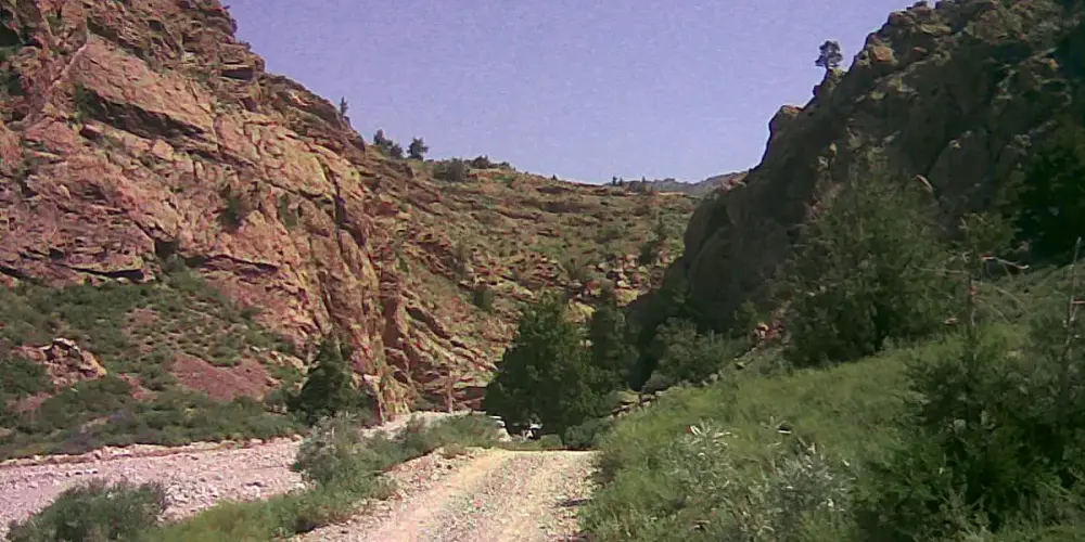
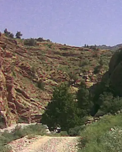
Chutair Tangi Ziarat
Chutair Tangi is one of the gorges along the road leads Ziarat City. Theare are more than six gorges around Ziarat, which are formed due to sprig water from the mountains. These natural streams in Balochistan are known as Karez.
Visiting Locations in Chutair Tangi Ziarat -
Danyor
Danyor is a tehsil in Gilgit District in Gilgit-Baltistan and located on elevation of 6,600 feet at the distance of 9 km from Gilgit City via the Nomal Road. It is also accessible via Karakoram Highway at an distance of 19 km on the opposite side of the Gilgit River.
Visiting Locations in Danyor -
Darel
Darel district is located along the Darel River at a distance of 443 KM from Islamabad and 226 KM from Gilgit city. It was created in the Diamer district in 2019. It includes all of the valleys along the Darel River. The Darel River is a tributary of the Indus River.
Visiting Locations in Darel -
Darkut Village
Darkut is the most beautiful and remote village in the Yasin Valley, located at the distance of 40 km from Yasin town. It is the last village of Pakistan in the Gilgit Baltistan in Gupis-Yasin district at the altitude of 8500 feet on the foot of Ghamubar Zom mountain. There are around 2000 people living in this village. It is a center point for number of important places such as Darkut Pass, Ghamubar Lake, Ghamubar Zom Glacier, etc.
Visiting Locations in Darkut Village -
Dera Ghazi Khan
Dera Ghazi Khan, known as D. G. Khan, is situated on the western bank of the Indus River on the foot of Sulaiman Mountains Range with an average height of 10,000 feet in South Punjab at the junction of four provinces. It is situated with the boundary of Balochistan, so number of Baloch people along with Saraikis are living there.
Visiting Locations in Dera Ghazi Khan -
Dera Ismail Khan
Dera Ismail Khan, also known as D. I. Khan, is situated on the right bank of the Indus River at the junction of the Gomal River. It is a borderline between Khyber Pakhtoonkhwa and Punjab and is located at the distance of 300 km from Peshawar city on Indus Highway N-55 via Kohat and Bannu.
Visiting Locations in Dera Ismail Khan -
Diamer
Diamer is the district of Gilgit-Baltistan at average elevation of 4,150 feet on the Karakoram Highway along the Indus River. It is the gateway to access the mighty mountains of Karakoram Range in Gilgit-Baltistan from Khyber Pakhtoonkhwa province. The Chilas is the capital town of the Diamer district.
Visiting Locations in Diamer -
Dina
Dina is a small town in the Jhelum District at the distance of 200km from Lahore on G. T. Road in the beginning of Pothohar Plateau. So its landscape is attractive with small size greenish mountains. The importance of this small town is due to the Mangla Dam in Mirpur Azad Kashmir on the Jhelum River, that is the one of the main energy production unit in Pakistan. Number of small small industries related to iron, wood or marble are participating in the development of Pakistan.
Visiting Locations in Dina -
Dir
Dir is located at a distance of 213 km from Peshawar on the foothills of the Himalayas and is accessible via Chakdara by Dir-Chitral Road and then following Dir-Malakand Road. It was a princely state and ruled by Nawab Shah Jehan Khan and merged with Pakistan in 1969. It is gateway to Chitral in north and to Swat in the east. In 1996, it was divided into Upper Dir district and Lower Dir district.
Visiting Locations in Dir -
Duikar
Duikar is the highest village at the altitude of 10,000 feet in Hunza valley and is located at the distance of 11 km from Karimabad. It is a very interesting point to visit due to its height and you will get a broader view of high mountain peaks in front of you. The most common peaks such as Rakaposhi, Lady Finger, Ultar, Golden peak, etc. can be viewed at this spot.
Visiting Locations in Duikar -
Dunga Gali
Dunga Gali is a very attractive place for the hiker and trekkers as it is the base camp of Mukshpuri top, 9,200 feet high mountain. Dunga Gali has located 87km from Rawalpindi and just after Ayubia, its average elevation is 9,000. There is also a wonderful 4km track from here to Ayubia, that has a lot of beautiful scenes on its trek.
Visiting Locations in Dunga Gali -
Eidgah Astore
Eidgah is the central and capital town of the Astore District at an elevation of 8,500 feet. Astore village and Rama Valley are important places for tourist near it. For tourist accommodation, there are a lot of hotels and rest-houses in the area.
Visiting Locations in Eidgah Astore -
Fort Munro
Fort Munro, also known as Tuman Leghari, is a beautiful hill station in the Sulaiman Mountain Range in Southern Punjab at an altitude of 6,470 feet above sea level, in Dera Ghazi Khan. It is located at a distance of 85 km from Dera Ghazi Khan city on Quetta Road. It is my favorite spot in summary due to its cool and pleasant atmosphere.
Visiting Locations in Fort Munro -
Gahkuch
Gahkuch is the capital of Ghizer at the distance of 72km from Gilgit City on Shandur Gilgit Road. It is surrounded by mountains on the bank of the Gilgit River. There are all types of accommodations including PTDC hotel for tourists. It is a lush green valley with high mountains. The view of the Gilgit River in Gahkuch is very of beauty due to the wideness of the river in this area. Another wonderful view is the confluence of the Gilgit River and the Ishkoman River.
Visiting Locations in Gahkuch -
Garam Chashma
Garam Chashma, the highest human settlement in the Hindu Kush Range, is the pleasant valley in Chitral at an altitude of 6,100 feet. It is located at a distance of 45 km from Chitral.
Visiting Locations in Garam Chashma -
Ghamubar Zom
Ghamubar Zom is mountain located in Hindu-Raj Range, a mountain range between Hindu Kush and the Karakoram ranges, at the elevation of 6,518 meters in the Darkut town in the Yasin Valley Gilgit-Baltistan. Its summit is entirely visible from Darkut and Rawat village, that is summer village for the Darkut people.
Visiting Locations in Ghamubar Zom -
Ghanche
Ghanche is the easternmost part of Gilgit-Baltistan and is situated on the banks of the Shyok River, at a distance of 306 km from Gilgit city via Skardu. It is the coldest place in Pakistan and is also known as the Third Pole with temperatures reaching below -20 centigrade. Its name is derived from a seasonal stream, called Ghanche Nallah.
Visiting Locations in Ghanche -
Ghizer
Ghizer district is located along the Gilgit River on the west of the Gilgit River. It is the most beautiful and attractive valley in Gilgit-Baltistan. It has a number of colorful valleys with singing streams within the green fields. It is the gateway to Chitral from the Gilgit side via Shandur Pass.
Visiting Locations in Ghizer -
Gilgit
Gilgit is a splendid place for tourists, situated at the altitude of 4800 feet in the southwest of Karakorum Range in the Gilgit-Baltistan Province near the confluence of the Gilgit River and Hunza River. It is the capital of the Gilgit-Baltistan province, which is an administrative territory of Pakistan.
Visiting Locations in Gilgit -
Gilgit Baltistan
Gilgit Baltistan is the fifth administrative part of Pakistan in its north side. Formaly it was part of Northern Areas, by the year 2009, it was granted limited autonomy under the Self-Governance Order of Government of Pakistan and renamed to Gilgit-Baltistan. Pakistan still not included it as a separate province due to Kashmir Movement in disputed Jammu and Kashmir held by India.
Visiting Locations in Gilgit Baltistan -
Gojal Upper Hunza
Gojal is the largest city in Baltistan next to Hunza, having a border with China and Afghanistan. It connects with China through the Khunjerab Pass and with Afghanistan through the Chapursan Valley. Gojal, also known as Upper Hunza, is the highest mountains area in the Karakoram and Pamir mountain ranges, at an average elevation of 4,000 meters.
Visiting Locations in Gojal Upper Hunza -
Gorikot
Gorikot is the capital and the largest valley of the Astore District. It is a gateway to Nanga Parbat Tarisheng Base camp and to Deosai Plain that link Astore to Skardu. It has lush green plains with beautiful scenic views in the high mountains in attractive colors. Roads from Gorikot are mostly suitable for Jeep but other vehicles can also be used but with some care. It is also famous for fruits and vegetable fields.Gorikot also provides accommodation facilities to stay the night there to start the further journey toward Deosai or Nanga Parbat.
Visiting Locations in Gorikot -
Gulmit
Gulmit, a historical town, is located in mountains, peaks, and glaciers in Gojal Upper Hunza, Gilgit Baltistan at the distance of 140 km from Gilgit on Karakoram Highway on the bank of the Hunza River.
Visiting Locations in Gulmit -
Gupis Yasin
Gupis Yasin is located in the west of Gilgit-Baltistan in the high mountains at an elevation of 7,139 feet in the Hindu Kush Range at a distance of 187 KM from the Gilgit main city. It is given the status of district in 2019 and separated from Ghizer district including Gupis, Yasin, and Phander.
Visiting Locations in Gupis Yasin