List of Balochistan cities
Balochistan is the largest province by area and located in the southwest side of Pakistan. Balochistan has the least number of popluation but has its importance due to vast mineral resouces including oil and gas. The natural gas resouces are the second largest resouces in the World. Another development in Balochistan is the deep sea port in Gwadar, which will be main transit point for international trade between China and rest of the World.
It provides an inclusive collections of beautiful pictures of Balochistan and all of the famous and attractive visiting places in it. Travel guide is also available to visit various cities or locations in Balochistan.
View Balochistan Districts
-
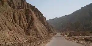
Awaran
Desert AreasAwaran is situated in the south of the Balochistan Province and is located at the distance of 725 km from Quetta city. It is accessible via Khuzdar on RCD Highway N-25 and Ratodero-Gwadar Motorway M-8, then turn on the Bela-Hoshab from Hoshab town to access Awaran district.
Visiting Locations in Awaran -
Barkhan
Historical SitesBarkhan is located at the distance of 418 km from Quetta city via Loralai on the National Highway N-70. Its landscape consists of plains, valleys and mountains having average elevation of 1,000 to 2,100 meters in the Sulaiman Mountain Range.
Visiting Locations in Barkhan -
Chagai
Mountaineous valleysChagai is the largest district of Pakistan and is situated on the north west part of Balochistan, at the distance of 560 km from Quetta city on the Quetta-Taftan Highway N-40. The importance of this district is due to international border between Iran and Pakistan at Taftan to link with Zahedan city in Iran.
Visiting Locations in Chagai -
Chaman
Mountain PassesChaman is situated in Balochistan with Kandahar, a city of Afghanistan, at the distance of 128 km from Quetta on National Highway N-25. It is the most important border crossing between Pakistan and Afghanistan, and most of the trade is conducted through it.
Visiting Locations in Chaman -
Dera Bugti
Desert AreasDera Bugti is situated at the distance of 365 km from Quetta city via Sibi through Quetta-Jacobabad Highway N-65, then following the Bhag-Dera Bugti Road. Dominant tribe in this district is Bugtis who has the main control of the district. It is mostly bounded by the dense hill structure of the Sulaiman Mountain Range.
Visiting Locations in Dera Bugti -
Dera Murad Jamali
Desert AreasDera Mura Jamil is a tehsil of Nasirabad district in Balochistan Province at a distance of 272 km from Quetta and is accessible via Sibi through Quetta-Jacobabad Highwary N-65 by crossing the historical Bolan pass. It lies on the fertile Indus Plains.
Visiting Locations in Dera Murad Jamali -
Gwadar
Sea PortsGwadar is a deep water port city in Balochistan on its south western coast on the Arabia Sea at the distance of 629 km from Karachi. Gwadar will be the next important sea port in the Arabian Sea due to construction of CPEC route from China to Gwadar port.
Visiting Locations in Gwadar -
Harnai
Historical SitesHarnai is situated at 166 km from Quetta on the Quetta Road in the northeast of Balochistan province. It is one of the most beautiful cities in Balochistan and is surrounded by different mountain ranges of the Sulaiman Mountain range on its all sides.
Visiting Locations in Harnai -
Jafarabad
Historical SitesJafarabad, or Jaffarabad, is located on the border of Sindh province at the distance of 290 km from Quetta city and is accessible via sibi on Quetta-Jacobabad Highway. Its name is derived after Mir Jaffar Khan Jamali, who was a leader in Muslim League before independence of Pakistan and also a close friend of Quaid-e-Azam, founder of Pakistan.
Visiting Locations in Jafarabad -
Jhal Magsi
Historical SitesJhal Magsi is a district of Balochistan province at a distance of 220 km from Quetta city via Quetta-Jacobabad Highway N-65. Historically, it was part of the princely state of Kalat during the British period. It has diversified land including mountain ranges, patches of lush green fields, and barren deserts.
Visiting Locations in Jhal Magsi -
Kacchi
Historical SitesKacchi is a district of Balochistan province at a distance of 175 km from Quetta city via Quetta-Jacobabad Highway N-65. It was known as Bolan until 2008. It is famous for the archeological site of Mehrgarh. It was remained as part of various dynasties in the central Balochistan and Afghanistan.
Visiting Locations in Kacchi -
Kalat
Mountaineous valleysKalat is a district in Balochistan Province at the distance of 141 km from Quetta on Karachi-Quetta Highway N-25. It was the main land of the princely state of the Khanate of Kalat from 1512 to 1955.
Visiting Locations in Kalat -
Kech
Historical SitesKech district is located at a distance of 770 km from Quetta and accessible via Kalat and turn left from Surab and following Quetta-Basima-Panjgur-Hoshab Highway N-85. It lies on the Makran Mountain range along the border with Iran.
Visiting Locations in Kech -
Kharan
Historical SitesKharan is a district in Balochistan at the distance of 280 km from Quetta on Kharan Road and accessed via Quetta-Taftan Highway N-40. It was a princely state during the British Regime and finally merges with Pakistan in 1955.
Visiting Locations in Kharan -
Khuzdar
Mountaineous valleysKhuzdar is located at the distance of 302 km from Quetta City on the Karachi-Quetta Highway N-25. It is a historical city and was the capital of the Khanate of Kalat that was a princely state of the Brahui Kingdom of Makran.
Visiting Locations in Khuzdar -
Killa Abdullah
Mountaineous valleysKilla Abdullah is a district in Balochistan Province at the distance of 105 km from Quetta. It is mountainuous region situated in the foothills of the Shela Bagh Range. It is accessible via Khojak tunnel or Khojak Pass through Chaman Road N-25.
Visiting Locations in Killa Abdullah -
Killa Saifullah
Historical SitesKilla Saifullah, or Qilla Saifullah, is a district in Balochistan Province at a distance of 188 km from Quetta and is accessible via Kuchlak through Kuchlak-Zhob Highway N-50. Its name is derived after Saifullah Khan Khoidadzai as in honour of his chivalry and nobility.
Visiting Locations in Killa Saifullah -
Kohlu
Historical SitesKahlu is a district in Balochistan Province at a distance of 350 km from Quetta. It is accessible by Ziarat Road via Ziarat district and following Duki Road which further joins Kohlu-Sibi Road that leads to Kohlu. There are numerous barren and desert like ranges of the Sulaiman Mountain Range in the district.
Visiting Locations in Kohlu -
Lasbela
Coastal AreasLasbela is a coastal district in Balochistan Province at the distance of 125 km from Karachi on the Karachi-Quetta Highway N-25. Lasbela is famous for its unique geographical structure of mountainous regions, largest national park in Pakistan, and the most beautiful beaches of the world.
Visiting Locations in Lasbela -
Loralai
Historical SitesLoralai, also known as Spin Bori, is a district in Balochistan at the distance of 215 km from Quetta at an elevation of 4,700 feet above sea level on Pishin-Loralai Road. Its old name was Bori. The district is also famous for the growth of best quality almond.
Visiting Locations in Loralai